![]()
2023-09-08, M6.8, Morocco
On the 8th of September 2023 at 22:11:01 UTC a M6.8 earthquake occurred in southwest Morocco at a depth of 19km. See map below for the earthquake epicentre, marked with a red circle. The earthquake struck in Morocco’s High Atlas mountains, about 75 km southeast of Marrakech. At the time of writing media outlets report of at least 600 fatalities mainly in mountain areas that are hard to reach.
This earthquake occurred within the Africa Plate, approximately 550 km south of the plate boundary between the Africa and Eurasia plates. The USGS estimates the fault area over which slip occurred to be about 30 by 20 km (length x width).

The M6.8 earthquake was recorded by seismic stations operated by DIAS in the Irish National Seismic Network (INSN), see figure below.

The earthquake was also detected by Raspberry Shake seismometers operated in Ireland by citizens and schools. The diagram below shows the data recorded by the station operated at St. Columba’s College in Stranorlar, Co. Donegal.

Further information can be obtained at the following links:
https://emsc.eu/Earthquake_information/earthquake.php?id=1550978
https://earthquake.usgs.gov/earthquakes/eventpage/us7000kufc/executive
2023-07-09, M5.2, Iceland
On the 9th of July at 22:22:57 UTC a M5.2 earthquake occurred in the Reykjanes peninsula in southwest Iceland, at a depth of 5km (see map below; the red circle denotes the earthquake epicentre). The Icelandic Meteorological Office (IMO) reported that the earthquake was proceeded by a seismic sequence between Fagradalsfjall and Keilir caused by a magmatic intrusion just north-east of the location of the 2021 and 2022 Fagradalsfjall eruptions. According to IMO the intrusion than led to a volcanic fissure eruption that started Monday the 10th July at 16:40 local time.
An eruption in the same area in 2021 saw lava flows and fountaining for months, with hundreds of thousands of people heading to see the volcanic activity. Icelandic Civil Defence said it is dangerous to visit the current eruption area because of gas pollution and people should stay away. The eruption site is located about half way between the capital Reykjavik and the town Grindavik on the southern coast of the Reykjanes peninsula.
At time of writing the Icelandic airport authority Isavia reported that no ash has been detected in connection with the eruption and there is therefore no impact on air traffic.

The M5.2 earthquake was recorded by seismic stations operated by DIAS in the Irish National Seismic Network (INSN), see figure below.

For further information about the earthquake see:
https://www.emsc-csem.org/Earthquake_information/earthquake.php?id=1526848
https://earthquake.usgs.gov/earthquakes/eventpage/us6000kr82/executive
Information about the volcanic eruption is available at:
https://en.vedur.is/about-imo/news/earthquake-activity-in-fagradalsfjall-area
https://www.ruv.is/english/2023-07-05-eruption-begins-387050

2023-02-24, M3.4, Wales
On the 24st of February 2023 an M3.4 earthquake occurred at 23:59:41 UTC approximately 30 km northwest of Newport in Wales, United Kingdom, see map below. The British Geological Survey (BGS) reported that the event was felt throughout the region, mainly within around 40 km of the earthquake epicentre.

The event was recorded by seismic stations in the Irish National Seismic Network (INSN), see figure below.

More information about the earthquake is available at the following resources:
https://www.emsc-csem.org/Earthquake/earthquake.php?id=1228525
https://earthquakes.bgs.ac.uk/earthquakes/recent_events/20230224235706.htm
2023-02-20, M6.4, Turkey
On the 20th of February 2023 at 17:04:29 (UTC) an M6.4 earthquake occurred in Southern Turkey near the border with Syria, about 15km southwest of Antakya and 5km from the Mediterranean Sea, see map below. The event struck in an area already affected by two strong earthquakes that hit two weeks earlier and caused more than 45,000 deaths and widespread destruction of infrastructure. The M6.4 event occurred at a relatively shallow depth of 10 to 15km and was felt as far as Egypt and Lebanon. Local sources report that several people have been killed and hundreds are injured due to collapsed buildings.

The event was recorded by seismic stations worldwide, including stations in the Irish National Seismic Network (INSN), see figure below.

More information about the earthquake is available at the following resources:
https://www.emsc-csem.org/Earthquake/earthquake.php?id=1226422
https://earthquake.usgs.gov/earthquakes/eventpage/us6000jqcn/
2022-06-21, M5.9, Afghanistan
On June 21, 2022 at 20:54:36 UTC a magnitude 5.9 earthquake occurred approximately 150km south of Kabul near the border with Pakistan (see map below). EMSC reports the earthquake originated at a depth of 10 kilometers. The earthquake caused widesoread damage with at least 300 fatalities and hundreds of injured. The event was felt widely to distances of 500km from the epicentre, including parts of Pakistan and India. Strong earthquakes in eastern Afghanistan result from the India plate moving northward and colliding with the Eurasia plate causing uplift producing high mountain ranges, including the Hindu Kush and the Himalaya.
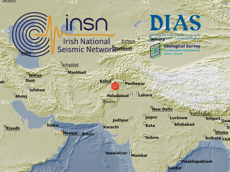
The event was recorded by seismic stations worldwide, including stations in the Irish National Seismic Network (INSN), see figure below.

For more information please see the links below:
https://www.emsc-csem.org/Earthquake/earthquake.php?id=1141004
https://earthquake.usgs.gov/earthquakes/eventpage/us7000hj3u
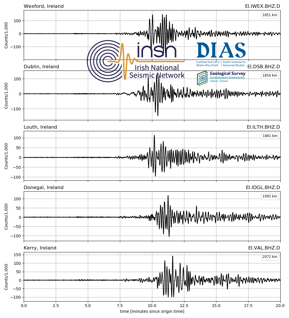
2021-08-14, M7.2, Haiti
At 12:29:09 GMT on the 14th August 2021 a magnitude 7.2 earthquake occurred about 125 km west of the Haitian capital Port-au-Prince, see map below. Extensive damage to buildings have been reported and it is feared that a large number of people died or have been injured. Previously, on the 12th January 2010 an M 7.0 earthquake struck in the same region of Haiti, about 75 km east from the 14th August 2021 event. According to the USGS “the 2010 earthquake caused substantial damage in the city of Port-au-Prince and the surrounding regions where damage from the earthquake and subsequent cascading hazards caused over 200,000 fatalities.”
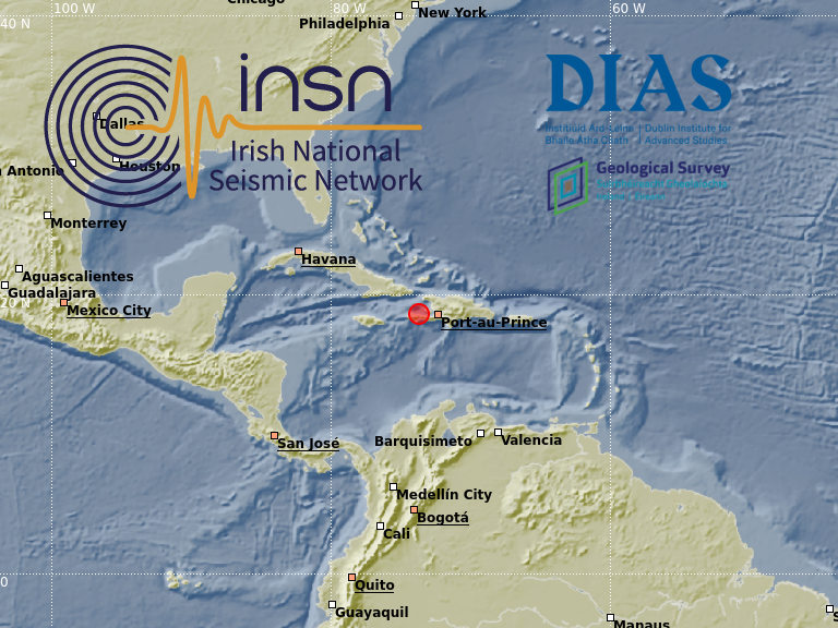
The event was recorded by seismic stations worldwide, including stations in the Irish National Seismic Network (INSN) (see figure below). The first seismic waves originating from the Haiti earthquake arrived ~10 minutes after the event origin. However, another large M7.0 earthquake occurred about 30 minutes before the Haiti earthquake on the Alaska peninsula. The seismic surface waves of the Alaska event dominate the first ~15 minutes of the seismograms shown below.

For more information on the M7.2 Haiti earthquake please see these links:
https://www.emsc-csem.org/Earthquake/earthquake.php?id=1023410
https://earthquake.usgs.gov/earthquakes/eventpage/us6000f65h
Information for the M7.0 Alska earthquake can be found here:
https://earthquake.usgs.gov/earthquakes/eventpage/ak021adyci6n
https://www.emsc-csem.org/Earthquake/earthquake.php?id=1023362
2021-02-10, M7.7, Loyalty Islands
At 13:20:00 (UTC) on the 10th February 2021, a magnitude 7.7 earthquake occurred southeast of the Loyalty Islands in the Pacific, see map below. The epicenter lies in a very remote region and only few people felt the event. The earthquake struck at a depth of 10 km and according to the Pacific Tsunami Warning Center a tsunami was triggered. Reported wave heights are 78cm in Vanuatu, 47cm at Norfolk Island, 29cm in New Caledonia and 22cm at the North Cape in New Zealand. At time of writing no fatalities or building damage were reported. The Loyalty Islands region is seismically very active, 15 other earthquakes with magnitudes larger than 7 were detected over the preceding century. This seismic activity is related to the plate boundary between the Australian and the Pacific plate.

The earthquake was recorded at seismic stations worldwide, including stations of the Irish Nation Seismic Network (INSN), see seismic waveforms below.

Further information is available from the following sources:
https://www.emsc-csem.org/Earthquake/earthquake.php?id=947612
https://earthquake.usgs.gov/earthquakes/eventpage/us6000dg77
2020-12-29, M6.4, Croatia
At 11:19:54 (UTC) on the 29th of December 2020, a magnitude 6.4 earthquake occurred in Croatia about 50km SE of the capital Zagreb, see map below. The earthquake nucleated at a relatively shallow depth of 10km within the Eurasia plate. It occurred after a magnitude 5.2 earthquake struck in the same area on the 28th December 2020 at 05:28 (UTC). At the time of writing at least one fatality was reported, at least 20 injured people and building damage especially in Petrinja, a town with about 25,000 inhabitants. Though earthquakes with magnitude over 6 happened before in Croatia this is the strongest event that was ever recorded in Croatia since modern seismic instrumentation is in use.Â
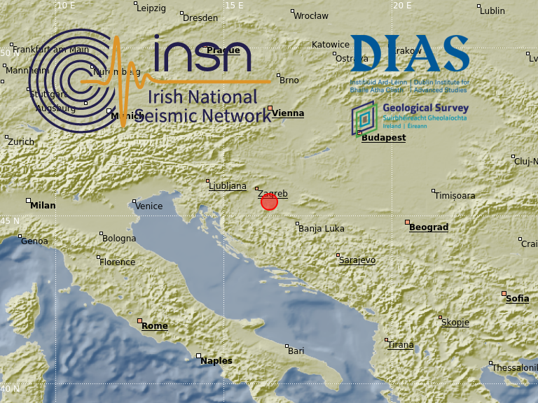
The earthquake was recorded at seismic stations worldwide, including stations of the Irish National Seismic Network (INSN), see seismic waveforms below.
Further information is available from the following sources:
https://www.emsc.eu/Earthquake/earthquake.php?id=933701
https://earthquake.usgs.gov/earthquakes/eventpage/us6000d3zh
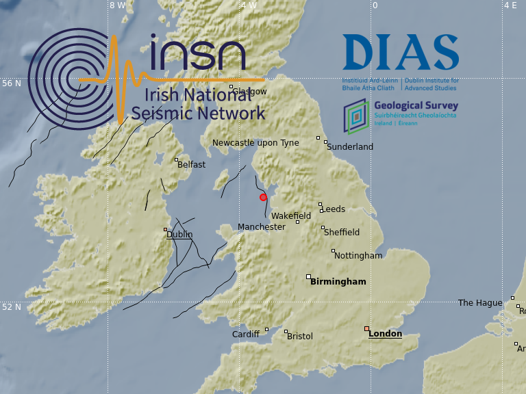
2020-04-25, M0.9, Irish Sea
On the 25th of April 2020 at 04:11:52 GMT, a magnitude M0.9 earthquake occurred in the Irish Sea approximately 15km off the English coast north of Blackpool. The epicentre location is indicated with a red circle in the map below, black lines denote major fault zones in and around Ireland. Events of this nature are not uncommon in the Irish Sea, a similar event with magnitude M1.7 occurred nearby on the 16th December 2019.
Seismic noise changes during Covid19
Instruments operated by the INSN track ground motions from natural phenomena, such as earthquakes, but also human-made ground vibrations, so-called ‘seismic noise’. After the lockdown started on the 28th March 2020, some INSN stations detected seismic noise levels significantly lower than before the lockdown. See figure below for seismic noise data from our station located in the Dublin mountains (click figure to enlarge).

Frequently Asked Questions:
What are seismometers for?
Seismometers respond to ground motion and are traditionally used to detect and locate earthquakes. The earthquake information in turn is used by seismologists and geologists to study the Earth’s interior.
What is seismic noise?
Seismic noise is a relatively persistent ground vibration that is not caused by earthquakes (Note: it is not a vibration in the air). Seismologist termed these signals ‘noise’ because they are a nuisance when trying to detect small earthquakes. Seismic noise has very low amplitude and cannot be felt by humans.
What can a seismometer not tell?
Seismometers do not distinguish between human made seismic noise, naturally made seismic noise (e.g. by strong wind) or seismic waves caused by an earthquake. Seismometers simply record ground vibrations no matter what caused them.
How do you know that the seismic noise is made by human activity?
Seismic noise can be caused by human activities like industrial works (e.g. large building sites, quarries, tunnelling), road traffic, rail traffic, airports, but it is also caused by natural phenomena like for example wind or water flow in a river. Human induced seismic noise is readily identified by its clear variation between day and night and also lower amplitudes on weekends.
Why does the diagram above stop at Sunday April 26th?
After Sunday 26th April 2020 seismic noise recorded at this station is dominated by more local noise sources (likely related to site machinery) and therefore it no longer gives an average regional picture.
Does human induced seismic noise originate just from traffic?
No. Large building sites, quarries, tunnelling, road traffic, rail traffic and airports are some other examples of sources for human induced seismic noise.
How far away can the vibrations still be detected?
This depends on the type of vibration source, more specifically on the strength and the frequency of the vibration causing the seismic noise waves. It is not possible to determine source distances or locations with a single station, but the spectral content of the data may indicate if the source is near or far. As an approximate guideline here are some numbers: Depending on rock type seismic noise originating from heavy industry can be detected up to distances of (approximately) 25km; from railways up to 15km; from motorways up to 6km; and from smaller roads up to 1km (International Handbook of Earthquake and Engineering Seismology, Part A, 2002, Edited by William H.K. Lee, Hiroo Kanamori, Paul C. Jennings, Carl Kisslinger, ISBN-10: 0124406521, ISBN-13: 978-0124406520).
How do you know its not a disturbance right beside the station?
Disturbances right beside a station show as very large amplitudes and don’t follow the smooth day/night variation that is observed for human induced noise from further afield.
Is this only seen in Ireland?
No. The effect of lockdown measures is observed at seismic stations worldwide, though only stations in or near urbanized areas show the effect, see for example https://www.nationalgeographic.com/science/2020/04/coronavirus-is-quieting-the-world-seismic-data-shows
Can you see this noise change all over Ireland?
No. Most of the seismic stations in Ireland operate at remote locations, away from urban areas, making them less sensitive to human induced seismic noise.
Why are seismologists interested in seismic noise?
In the 1990s methods were developed to derive ground properties from seismic noise data. In addition noise data are now widely used to monitor natural processes, for example ocean wave state, volcano activity and water flow at inaccessible locations like in caves and glaciers.
On the 10th April 2020 Martin Möllhoff gave this interview about seismic ground vibrations on Tipp FM:

VAL - Kerry


IMAY - Mayo
