Home » Recent Local Earthquake (Page 3)
Category Archives: Recent Local Earthquake
![]()
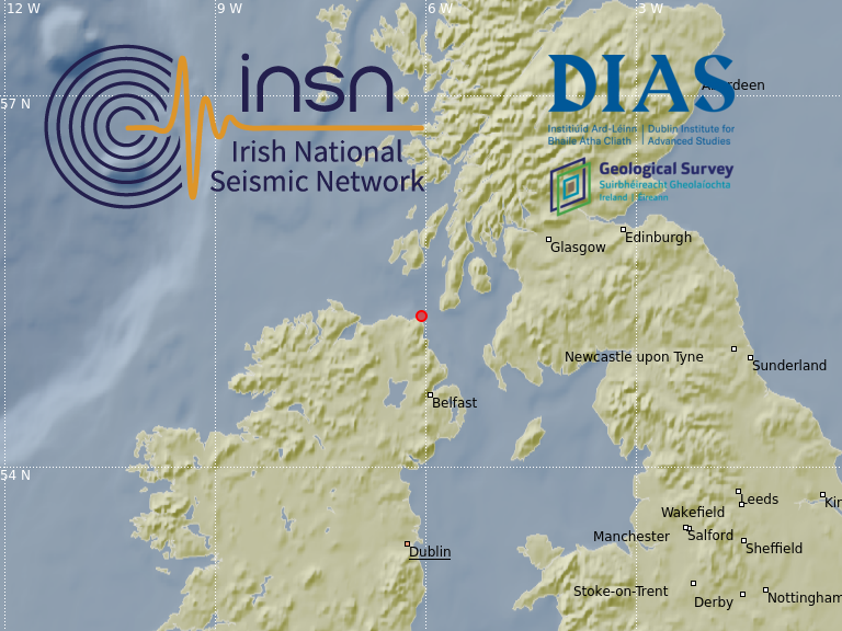
2020-01-29, M1.0, Offshore Antrim
On the 29th January 2020 at 07:27:40 GMT a magnitude M1.0 earthquake occurred offshore Co. Antrim, Northern Ireland. The earthquake located close to the epicentres of the M0.9 earthquake, 26th January 2020 and the M1.6 earthquake, 18th of December 2019. In the map below the epicentre of the M1.0 earthquake is indicated with a red marker. Major fault zones in and around Ireland are shown with black lines.

The event was recorded by the Irish National Seismic Network (INSN) and British Geological Survey (BGS) seismometers, for seismograms see the plot below (click image to enlarge).

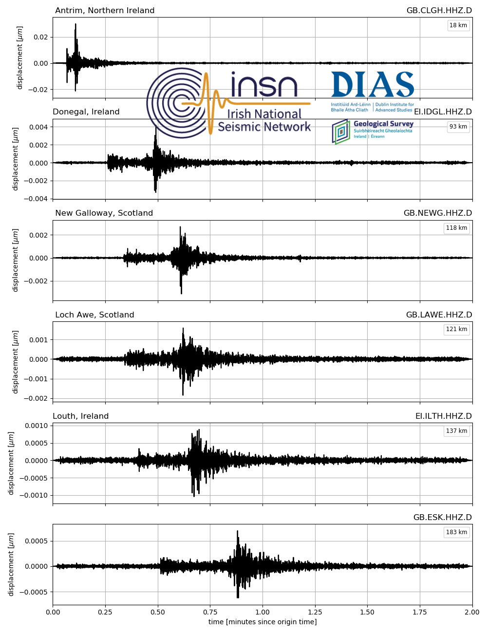
2020-01-26, M0.9, Offshore Antrim
On the 26th January 2020 at 22:27:19 GMT a M0.9 earthquake occurred offshore Co. Antrim, Northern Ireland. The earthquake located approximately 10km east of both Ballycastle and Rathlin Island, very close to the location of the M1.6 earthquake that occurred on the 18th of December 2019 at 20:22:14 GMT.

The event was recorded by the Irish National Seismic Network (INSN) and British Geological Survey (BGS) seismometers, and can be seen in the waveforms plotted below:
2019-12-20, M1.4, Irish Sea
On the 20th of December 2019 at 09:53:44 local time, a M1.4 earthquake occurred in the Irish Sea approximately 90km north-east of Dublin and 40km south of the Isle of Man. The epicentre location is shown in the map below. This event follows a M2.5 earthquake in the Irish Sea from the 15th of December 2019. The M1.4 earthquake is most likely an aftershock of the recent M2.5 earthquake.

The event was recorded by the Irish National Seismic Network (INSN) and British Geological Survey (BGS) seismometers, and can be seen in the waveforms plotted below:

2019-12-18, M1.6, Offshore Antrim
On the 18th of December 2019 at 20:22:14 UTC, a M1.6 earthquake occurred offshore Co. Antrim, Northern Ireland. The earthquake located approximately 10km east of both Ballycastle and Rathlin Island, and at a depth of 1km. Since 2010, the Irish National Seismic Network (INSN) has previously recorded 5 earthquakes off the Antrim Coast, the largest of which was an M1.6 earthquake occurring on the 26th of October 2013.
The event was recorded by the Irish National Seismic Network (INSN) and British Geological Survey (BGS) seismometers, and can be seen in the waveforms plotted below:

The INSN is operated by the Dublin Institute for Advanced Studies (DIAS) in co-operation with the Geological Survey Ireland (GSI).
2019-12-15, M2.5, Irish Sea
On the 15th of December 2019 at 21:19:52 local time, a M2.5 earthquake occurred in the Irish Sea approximately 90km north-east of Dublin and 40km south of the Isle of Man. The epicentre location is shown in the map below. Events of this nature are not uncommon in the Irish Sea, a similar smaller event occurred on the 17th of November 2019. There has also been a subsequent M1.7 event at 06:23:55 on the 16th December off the English coast North of Blackpool (see map at bottom of page).

There have been no reports that the earthquake was felt onshore but the event was recorded by the Irish National Seismic Network (INSN) seismometers, and can be seen in the waveforms plotted below.
 The INSN is operated by the Dublin Institute for Advanced Studies (DIAS) in co-operation with the Geological Survey Ireland (GSI).

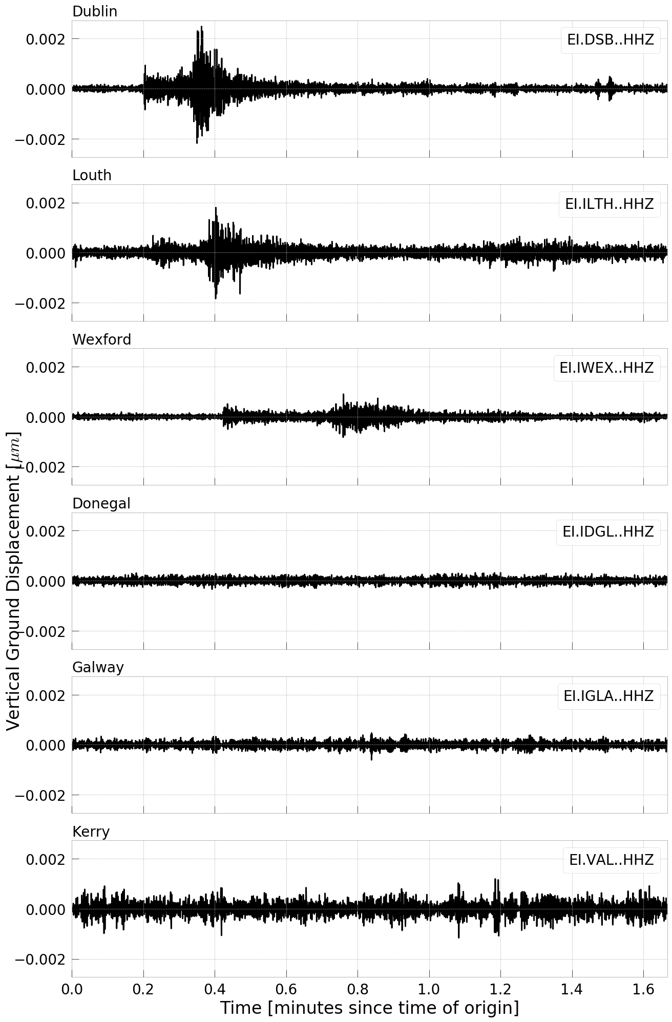
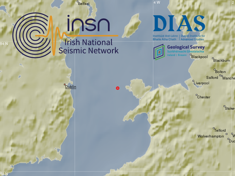
2019-11-17, M1.2, Irish Sea
On the 17th of November 2019 at 14:56:08 local time a M1.2 earthquake occurred in the Irish Sea approximately 50km north-east of Dublin. The epicentre location is shown in the map below.

The event was too weak to be felt but was recorded by the Irish National Seismic Network (INSN) seismometers, and can be seen in the waveforms plotted below (most obviously on the eastern stations of Dublin, Louth and Wexford).
The INSN is operated by the Dublin Institute for Advanced Studies (DIAS) in co-operation with the Geological Survey Ireland (GSI).
2019-06-18, M1.9, Irish Sea
On the 18th of June 2019 at 20:53:12 local time (19:53:12 UTC) a M1.9 earthquake occurred in the Irish Sea approximately 15km west off Holyhead in Wales. The epicentre location is shown in the map below. The earthquake was detected by the Irish National Seismic Network (INSN) which is operated by the Dublin Institute for Advanced Studies (DIAS) in co-operation with the Geological Survey Ireland (GSI). The INSN did not receive any felt reports for this event.
The earthquake was detected by seismic stations of the Irish National Seismic Network (INSN) and the British Geological Survey (BGS), see seismograms below.

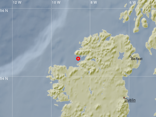
2019-04-29, M2.1 Donegal
On the 29th April 2019 at 21:18:23 local time (20:18:23 GMT) an earthquake of magnitude 2.1 occurred in Donegal. The location of the epicentre is 54.56N, 7.96W, about 15km south-east from Donegal town and 15km north-east from Ballyshannon, see figure below. The earthquake was detected automatically by the Irish National Seismic Network (INSN) which is operated by the Dublin Institute for Advanced Studies (DIAS) in co-operation with the Geological Survey Ireland (GSI). The event was felt by members of the public in the south of Co. Donegal and parts of Co. Fermanagh and Co. Leitrim, see map at the bottom of this post. If you felt or heard this event please consider clicking here to fill out a small report. Short interviews about the earthquake were given by Dr Martin Möllhoff, Director of Seismic Networks at DIAS, in this ‘News at One’ bulletin on Radio RTE 1 and on OceanFM.
The event was recorded on the stations of the Irish National Seismic Network (INSN), see seismic traces below. Some stations from the BGS network in the UK detected the event as well.


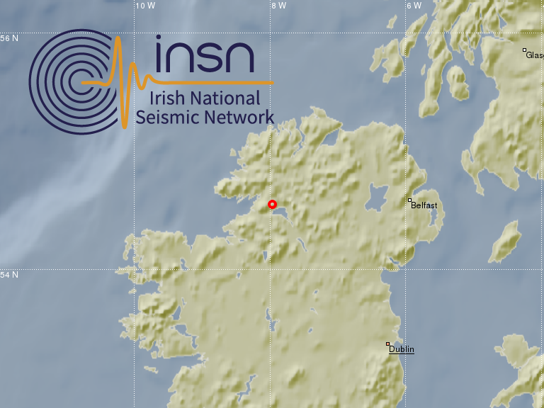
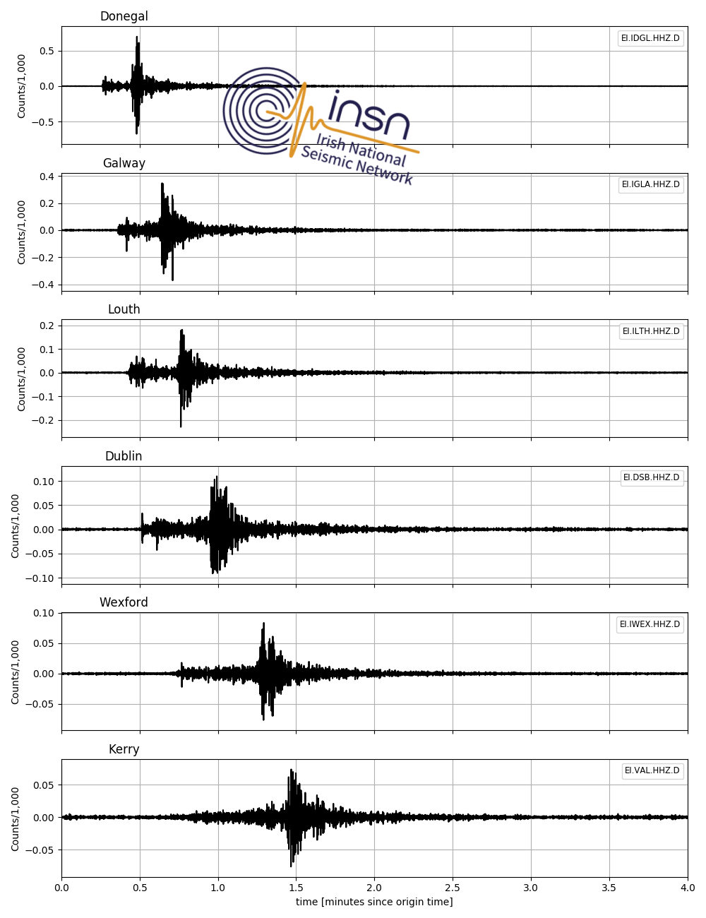
2019-04-07, M2.4 Donegal
On the 7th April 2019 at 23:58:19 local time (22:58:19 UTC) an earthquake of magnitude 2.4 occurred in Donegal. The location of the epicentre is 54.53N, 8.62W, see figure below. The event was felt widely by members of the public around the Killybegs area in the south west of Co. Donegal. The eartqhauke was detected automaticaly by the Irish National Seismic Network (INSN) which is operated by the Dublin Institute for Advanced Studies (DIAS) in co-operation with the Geological Survey Ireland (GSI). Events of this nature are not uncommon in the region, however earthquakes with magnitudes larger than 2 are recorded only every few years onshore Ireland or near it’s coast. Follow this link to listen to a radio interview given on the 8th April by Dr. Martin Möllhoff, Director of Seismic Networks at DIAS, on the RTE Radio 1 programme Drivetime.
The event was recorded on the stations of the Irish National Seismic Network (INSN) see seismic traces below. Stations from the BGS network in the UK detected the event as well.
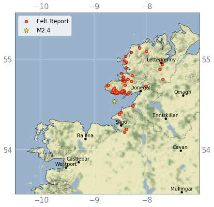
The INSN received more than 100 reports from members of the public who felt the earthquake. The map below shows the location of some of these reports, if you experienced this event please consider clicking here to fill out a small report. Thank you!
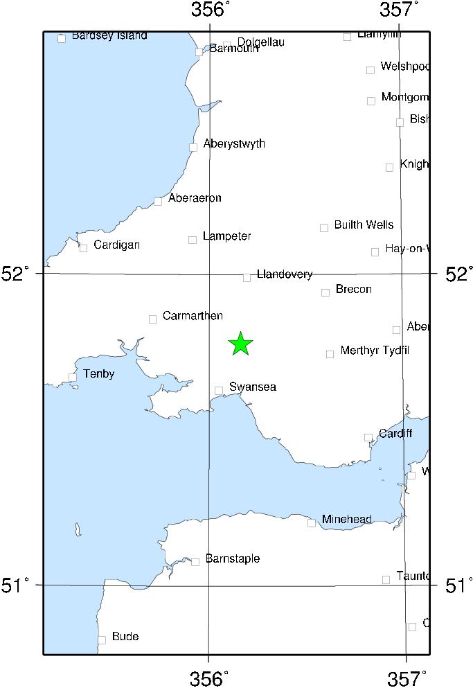
2018-02-17, M4.4 South Wales
On the 17th February 2018 an earthquake with magnitude 4.4 occurred at 14:31:07.6 UTC at a depth of 7.4km in South Wales about 20km north of Swansea, see map below. According to the BGSÂ hundreds of members of the public submitted felt reports. Events of this magnitude happen in the UK only about every 2 to 3 years. The BGS reports that this is the biggest event in the area since a magnitude 5.2 earthquake in 1906.

The earthquake was recorded at stations of the Irish National Seismic Network (INSN), see seismic waveforms below (select figure to enlarge).

Further information about this event is available from the following webpages:
BGS: http://earthquakes.bgs.ac.uk/earthquakes/recent_events/20180217142554.html#page=summary
EMSC: https://www.emsc-csem.org/Earthquake/earthquake.php?id=649041
GFZ: http://geofon.gfz-potsdam.de/eqinfo/event.php?id=gfz2018dizj
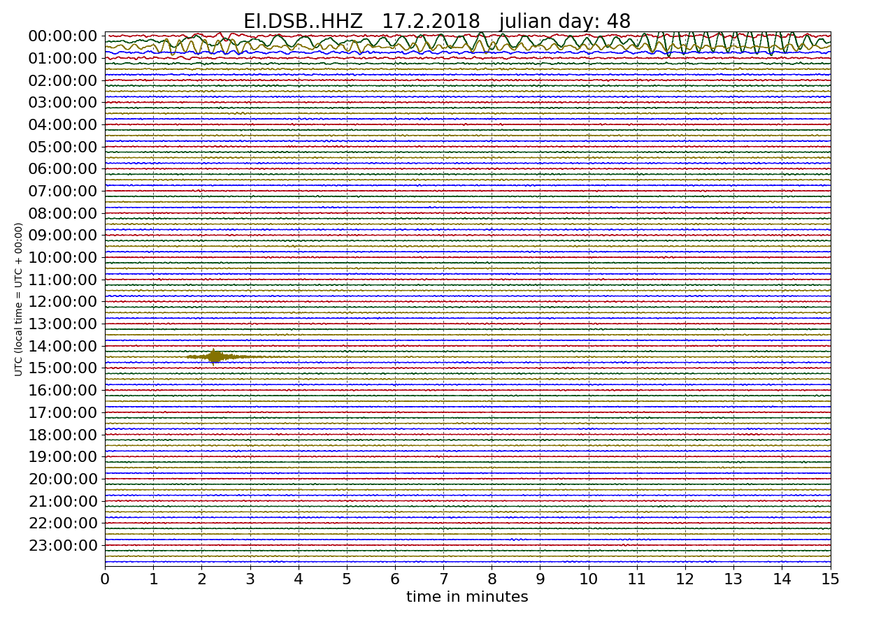
The drumplot below shows the unfiltered seismic signal recorded on the 17th February 2017 at INSN station DSB in the Dublin mountains. The high amplitude low frequency signals between midnight and 1 a.m. are the surface waves of the M7.2 Mexico earthquake that occurred on the 16th February 2018 at 23:39:39, see https://www.insn.ie/2017-02-16-m7-2-mexico for more details on that event. The magnitude 4.4 event with epicentre in South Wales can be seen with much higher frequency content around 14:32.
More information about the INSN is available via this link.

VAL - Kerry


IMAY - Mayo
