Home » Posts tagged 'global earthquake' (Page 2)
Tag Archives: global earthquake
![]()
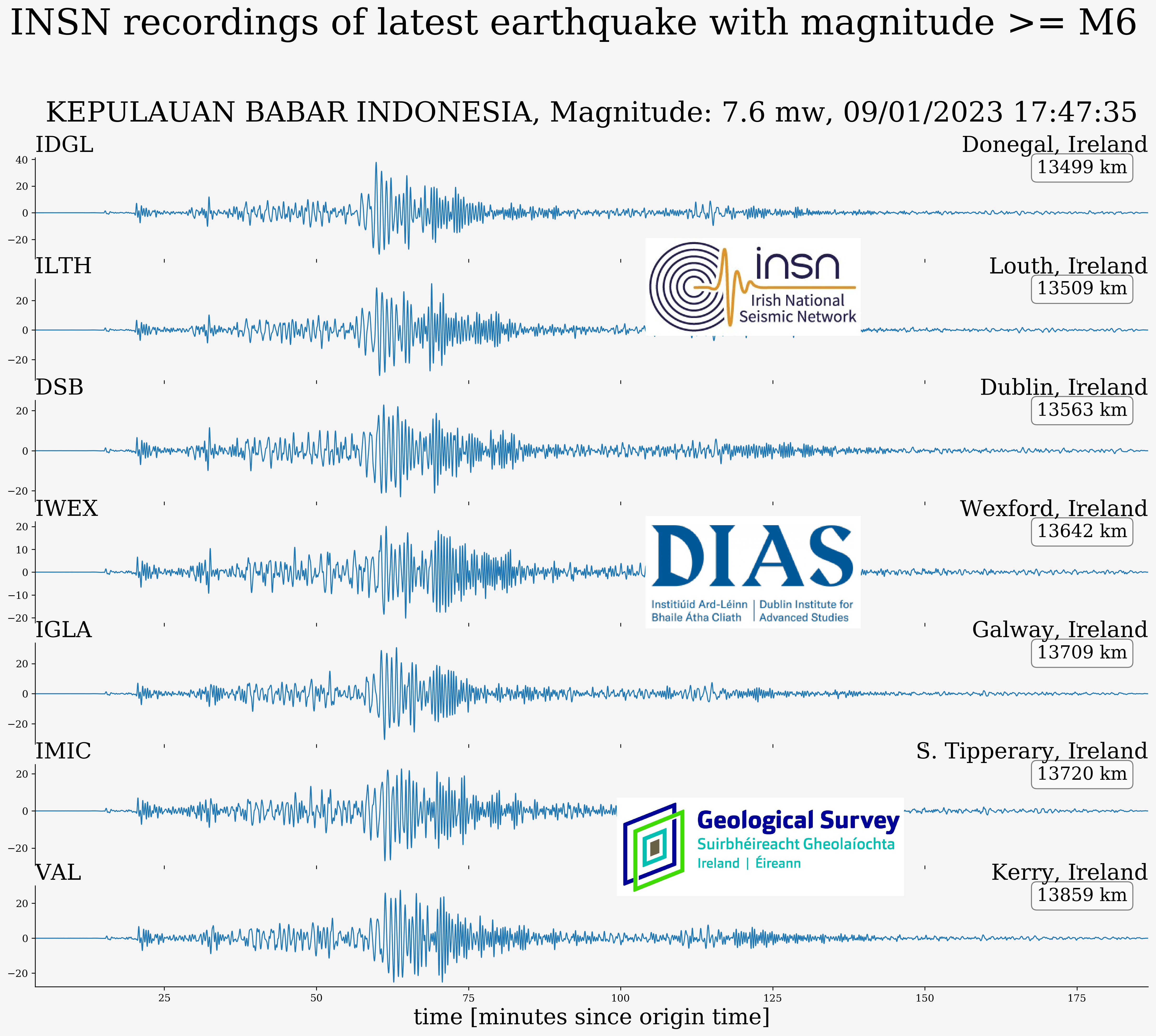
2023-01-09, M7.6, Indonesia
On the 9th of January 2023 an M7.6 earthquake occurred in the Tanimbar region of Indonesia (see map below). Several aftershocks were also reported after the powerful quake that was also felt in some parts of northern Australia.

Indonesia is positioned at the boundary of 3 tectonic plates (the Indian-Australian, Eurasian and Pacific plates). The plate boundaries are long and found beneath the ocean, meaning large and shallow earthquake can be generated from this zone that may potentially generate tsunami.
The event was recorded by seismic stations worldwide, including stations in the Irish National Seismic Network (INSN), see figure below.
More information is available at the following resources:
https://www.emsc-csem.org/Earthquake/earthquake.php?id=1208699
2022-12-20, M6.4, California
On the 20th of December 2022, an M6.4 earthquake occurred in the United States of America at 10:34:24 UTC approximately 15km WSW of Ferndale, California (see map below). At least two deaths have been recorded and several injuries. The earthquake also caused damage to buildings and interrupted the power and water supply in the area.

The event was recorded by seismic stations worldwide, including stations in the Irish National Seismic Network (INSN), see figure below.

More information is available at the following resources:
https://earthquake.usgs.gov/earthquakes/eventpage/nc73821036/executive
2022-11-21, M5.6, Indonesia
On the 21st of November 2022, an M5.6 earthquake occurred at 06:21:11 UTC approximately 18 km WSW of Ciranjang-hilir, Indonesia, see map below. The event occurred in a densely populated region and resulted in over 200 fatalities and over 1,000 injured people largely due to buildings collapsing.
This is a highly seismically active region, close to the subductive plate boundary between the Australia and Sunda plates. The earthquake occurred within the crust of the Sunda plate approximately 260km northeast of the boundary.

More information is available at the following resources:
https://earthquake.usgs.gov/earthquakes/eventpage/us7000ir9t/executive
https://www.bmkg.go.id/gempabumi/gempabumi-terkini.bmkg?lang=EN
https://www.emsc-csem.org/Earthquake/earthquake.php?id=1191326
2022-09-19, M7.6, Mexico
On the 19th of September, 2022, at 18:05:08 UTC a magnitude M7.6 earthquake occurred in the Michoacan region of Mexico. The earthquake struck approximately 110 km SE of the city of Colima (pop: 150,000), with the red circle indicating the epicentre on the map below. USGS reports the earthquake originated at a depth of 15 kilometers. At the time of writing the earthquake caused at least 2 deaths.

Tectonically, southern Mexico lies along the boundary between the North American plate and Cocos plate to the south. The subduction of the Cocos plate beneath the North American plate results in many large earthquakes in this region. Coincidentally, two other major earthquakes occurred in this region on the same date: the devastating M8.0 Mexico City earthquake on Sept 19th 1985 in which over 5,000 people died, and M7.1 Mexico City earthquake on Sept 19th 2017 which caused 360 fatalities.
The event was recorded by seismic stations worldwide, including stations in the Irish National Seismic Network (INSN), see figure below.

2022-07-27, M7.0, Philippines
On July 27, 2022, at 00:43:24 UTC a magnitude 7.0 earthquake occurred in the island of Luzon in the Philippines. The earthquake struck approximately 84 km SSE of the city of Laoag (pop: 102,000) and 15 km NE of San Ramon (pop: 4,000), see map below. EMSC reports the earthquake originated at a depth of 10 kilometers. At the time of writing the earthquake caused at least 2 deaths and dozens of injuries have been reported.

The tectonics of the region are complex and prone to large earthquakes. Luzon is on the Philippines sea-plate which is bounded to the East and West by subduction zones. According to the USGS the region experiences high seismicity rates and since 1970, 11 other earthquakes of magnitude 6.5 or larger have occurred within 250 km of the July 27, 2022 earthquake. The largest of these earthquakes occurred in 1990 (M7.7) and killed more than 1,600 people.
The event was recorded by seismic stations worldwide, including stations in the Irish National Seismic Network (INSN), see figure below.

More information is available at the following resources:
https://earthquake.usgs.gov/earthquakes/eventpage/us6000i5rd/region-info
https://www.emsc-csem.org/Earthquake/earthquake.php?id=1153080
2022-06-21, M5.9, Afghanistan
On June 21, 2022 at 20:54:36 UTC a magnitude 5.9 earthquake occurred approximately 150km south of Kabul near the border with Pakistan (see map below). EMSC reports the earthquake originated at a depth of 10 kilometers. The earthquake caused widesoread damage with at least 300 fatalities and hundreds of injured. The event was felt widely to distances of 500km from the epicentre, including parts of Pakistan and India. Strong earthquakes in eastern Afghanistan result from the India plate moving northward and colliding with the Eurasia plate causing uplift producing high mountain ranges, including the Hindu Kush and the Himalaya.
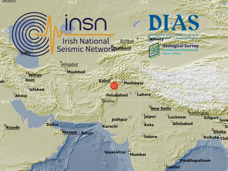
The event was recorded by seismic stations worldwide, including stations in the Irish National Seismic Network (INSN), see figure below.

For more information please see the links below:
https://www.emsc-csem.org/Earthquake/earthquake.php?id=1141004
https://earthquake.usgs.gov/earthquakes/eventpage/us7000hj3u
2022-03-21, M5.2, North Sea
On the 21st of March 2022 at 06:32 UTC a magnitude M5.2 earthquake occurred in the North Sea, approximately 205 km WNW of Bergen, Norway. The earthquake located with a depth of 10 km and was reported felt from the western parts of southern Norway. The earthquake location is indicated by the red circle in the map below. The North Sea has low to intermediate seismicity with the majority of it occurring along the Norwegian coastline. Events are generally below M3 however a similar magnitude event was recorded in the same region on the 24th January 1927.

The event was recorded by seismic stations worldwide, including stations in the Irish National Seismic Network (INSN) (see figure below). The first seismic waves originating from the North Sea earthquake arrived in Ireland ~2 minutes after the event origin.

For more information on the North Sea earthquake please see these links:
https://earthquake.usgs.gov/earthquakes/eventpage/us6000h6bi/executive
https://www.emsc-csem.org/Earthquake/earthquake.php?id=1109087
2022-03-16, M7.3, Japan
At 14:36:33 (UTC) on the 16th of March 2022 a magnitude 7.3 earthquake occurred near the east coast of Honshu Japan, 57 km east-north-east of Namie which is located in Fukushima Prefecture (see map below). The NWS Pacific Tsunami Warning Center initially issued a warning for hazardous waves along the coast of Japan but now reports the threat from this event has passed. The Tokyo Electric Power Company reports over 2 million households in nine prefectures have been left without electricity due to the earthquake.

Japans tectonic setting is complex as it is influenced by the North America plate, Pacific plate, Philippine Sea plate, and Eurasian plate. A detailed summary of the region is available from the USGS at the following link https://earthquake.usgs.gov/earthquakes/eventpage/us6000h519/region-info.
The event was recorded by seismic stations worldwide, including stations in the Irish National Seismic Network (INSN) (see figure below). The first seismic waves originating from the Japan earthquake arrived in Ireland ~15 minutes after the event origin.

For more information on the M7.3 Japan earthquake please see these links:
https://www.jma.go.jp/bosai/map.html#5/38.393/143.174/&elem=warn&contents=tsunami&lang=en
http://geofon.gfz-potsdam.de/eqinfo/event.php?id=gfz2022fgid
https://www.emsc-csem.org/Earthquake/earthquake.php?id=1107417
2021-07-29, M8.2, Alaska
On July 29, 2021 at 06:15 UTC (July 28, 2021 22:51 local time) a magnitude 8.2 earthquake occurred approximately 80km south of the Alaska Penninsula (see map below). The USGS report the earthquake originated at a depth of 32 kilometers. Large earthquakes are common in this region as a result of thrust faulting at shallow depth on the subduction zone interface between the Pacific plate and the North America plate.
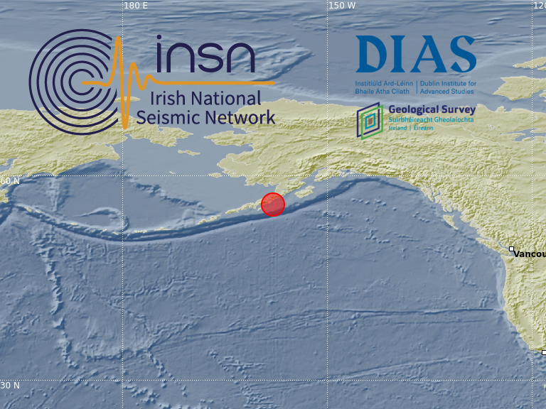
The event was recorded by seismic stations worldwide, including stations in the Irish National Seismic Network (INSN) (see figure below). The first seismic waves originating from the Alaska earthquake arrived ~6 minutes after the event origin.

For more information please see the links below:
https://www.usgs.gov/news/magnitude-82-earthquake-alaska
https://www.emsc-csem.org/Earthquake/earthquake.php?id=1014588
2020-07-22, M7.8, Alaska Peninsula
At 06:12:44 (UTC) on the 22nd of July 2020, a magnitude 7.8 earthquake occurred  near the Alaska Peninsula (see map below). The earthquake struck approximately 100 km south of the peninsula at a depth of 30 km. Shortly after, a tsunami warning was issued by the U.S. Tsunami Warning System. Several aftershocks of magnitude 5 and greater occurred within the hours following the main shock. Large earthquakes are common in this region due to the subduction of the Pacific plate beneath the North American plate. Since 1900, twelve earthquakes with magnitudes greater than 7.5 have occurred in this region, including the 1964 M9.2 Prince William Sound earthquake, the second largest recorded earthquake in the era of modern instrumental seismology.
The earthquake was recorded at seismic stations worldwide, including stations of the Irish Nation Seismic Network (INSN), see seismic waveforms below (select figure to enlarge).
Further information is available from the following sources:
https://www.emsc-csem.org/Earthquake/earthquake.php?id=878808
https://earthquake.usgs.gov/earthquakes/eventpage/us7000asvb/executive

VAL - Kerry


IMAY - Mayo
