Home » Posts tagged 'Irish National Seismic Network' (Page 2)
Tag Archives: Irish National Seismic Network
![]()
2023-05-10, M2.4, Goban Spur, North Atlantic
On the 10th of May 2023 at 16:21:53 UTC, a magnitude M2.4 earthquake occurred near the Goban Spur, in the Porcupine region of the North Atlantic ocean, locating approximately 350km south-south-west off the coast of Kerry. The earthquake occurred at a depth of 10 km. The location of the epicentre is indicated with a red circle in the map below. While earthquakes are known to occur in this region, it is not often that they are detected. As almost all seismometers are land-based, only larger magnitude events (M > 2) are seen from this region. Several earthquakes of similar magnitudes (between M2.0 and M4.4) have been detected in this region since 1980. Previously, the most recent earthquake detected from this area occurred on 2022-03-10 (M3.4, in the Porcupine Abyssal Plain), and the largest earthquake detected (since 1980) in the Porcupine region was M4.4, occurring on the 17th of February 1980.

The event was recorded by the Irish National Seismic Network (INSN) and can be seen in the waveforms plotted below:

2023-05-06, M2.5, Donegal
At 00:32 UTC on the 6th of May 2023 an M2.5 earthquake occurred at a depth of approximately 10 km. The event occurred near Glenveagh National Park in northwest Donegal, Ireland (see map below). The Irish National Seismic Network (INSN) operated by DIAS has received reports that the event was felt throughout the Donegal area.

The event was recorded by seismic stations operated by DIAS in the Irish National Seismic Network (INSN), see figure below.

If you felt this event, please consider making a report at https://www.insn.ie/you-felt-a-seismic-event/questionnaire/
The map below shows the locations from where the INSN received felt event reports. Nearly 300 reports of the event being felt or heard were received, particularly from Letterkenny, Ballybofey and Dungloe. Approximately 85% of respondents heard the earthquake, 76% felt the earthquake and 32% were awakened by the earthquake.

The earthquake was also detected by several Raspberry Shake seismometers operated in Ireland by citizens and schools. The plot below shows the recorded data, the distance between each station and the epicentre is shown in the top right corner of each sub-panel.

Below we show the seismogram and spectrogram for the the citizen station AM.R0FF0 (located in Sligo) as generated by the Raspberry Shakenet mobile app.

2023-03-21, M6.5, Afghanistan
On the 21st of March 2023 a M6.5 earthquake occurred in the Hindu Kush region of Afghanistan (see map below). The earthquake occurred at 16:47:24 UTC (21:17:24 local time) an occurred at a depth of 193 km. At least 13 people died (at the time of writing), with reports of damaged buildings and landslides in northern Afghanistan and Pakistan as a result of the earthquake. Seismicity in this region is largely due to the continental collision of the India and Eurasia plates, with several major earthquakes (>M7) occurring regularly.


More information is available at the following resources:
https://www.emsc-csem.org/Earthquake/earthquake.php?id=1240146
https://earthquake.usgs.gov/earthquakes/eventpage/us7000jln7/executive
2023-03-04, M3.0, Rockall Plateau
On the 4th of March 2023 at 03:45 UTC a magnitude M3.0 earthquake occurred in the Rockall Plateau in the North Atlantic, approximately 600km northwest of Donegal. The earthquake located with a depth of 10 km. In the map below the epicentre of the earthquake is indicated with a red marker. Major fault zones in and around Ireland are shown with red lines. While earthquakes in the Rockall Trough are regularly detected by the INSN, only one previous event has been detected from the Rockall Plateau – a M3.5 earthquake from the 10th of January 2016. As the nearest land-based seismometers are 500km from the Rockall Plateau, only larger magnitude (M2.5+) events are expected to be detected from this region. Earthquakes with magnitudes up to M4 are known to occur in the Rockall Trough.

The event was recorded by the Irish National Seismic Network (INSN) and can be seen in the waveforms plotted below:

2023-02-06, M7.8, M7.5, Turkey
On the 6th of February 2023 at 01:17:35 (UTC) an M7.8 earthquake occurred in South-Eastern Turkey (see map below). The event effected Turkey, Syria and surrounding areas. The earthquake struck 30 km WNW of Gaziantep, Turkey and 108 km NNW of Aleppo, Syria, both of which are densely populated areas. Several strong aftershocks have also been observed in the region, notably a magnitude M7.5 about 100km north of Gaziantep at 10:24:49 (UTC) the same day. Over five thousand deaths and many injured, largely due to building collapse, have been reported. The M7.8 and M7.5 earthquakes occurred at depths of 18km and 10km respectively. Such large, shallow earthquakes produce significant ground shaking.
For a radio interview on RTE Radio 1 titled “Why is Turkey so prone to earthquakes?” with Chris Bean, Head of Geophysics at DIAS follow this link: https://www.rte.ie/radio/radio1/clips/22208567/
Chris Bean also talked on The Pat Kenny Show on Newstalk radio, the clip can be accessed here: https://www.insn.ie/wp-content/uploads/2023/02/The-Paty-Kenny-Show-7th-Feb-2023-Chris-Bean.mp3

The event was recorded by seismic stations worldwide, including stations in the Irish National Seismic Network (INSN), see figure below.

More information about the M7.8 earthquake is available at the following resources:
https://earthquake.usgs.gov/earthquakes/eventpage/us6000jllz
https://www.emsc-csem.org/Earthquake/earthquake.php?id=1218444
Information about the M7.5 earthquake is available at these sites:
https://earthquake.usgs.gov/earthquakes/eventpage/us6000jlqa
https://www.emsc-csem.org/Earthquake/earthquake.php?id=1218771
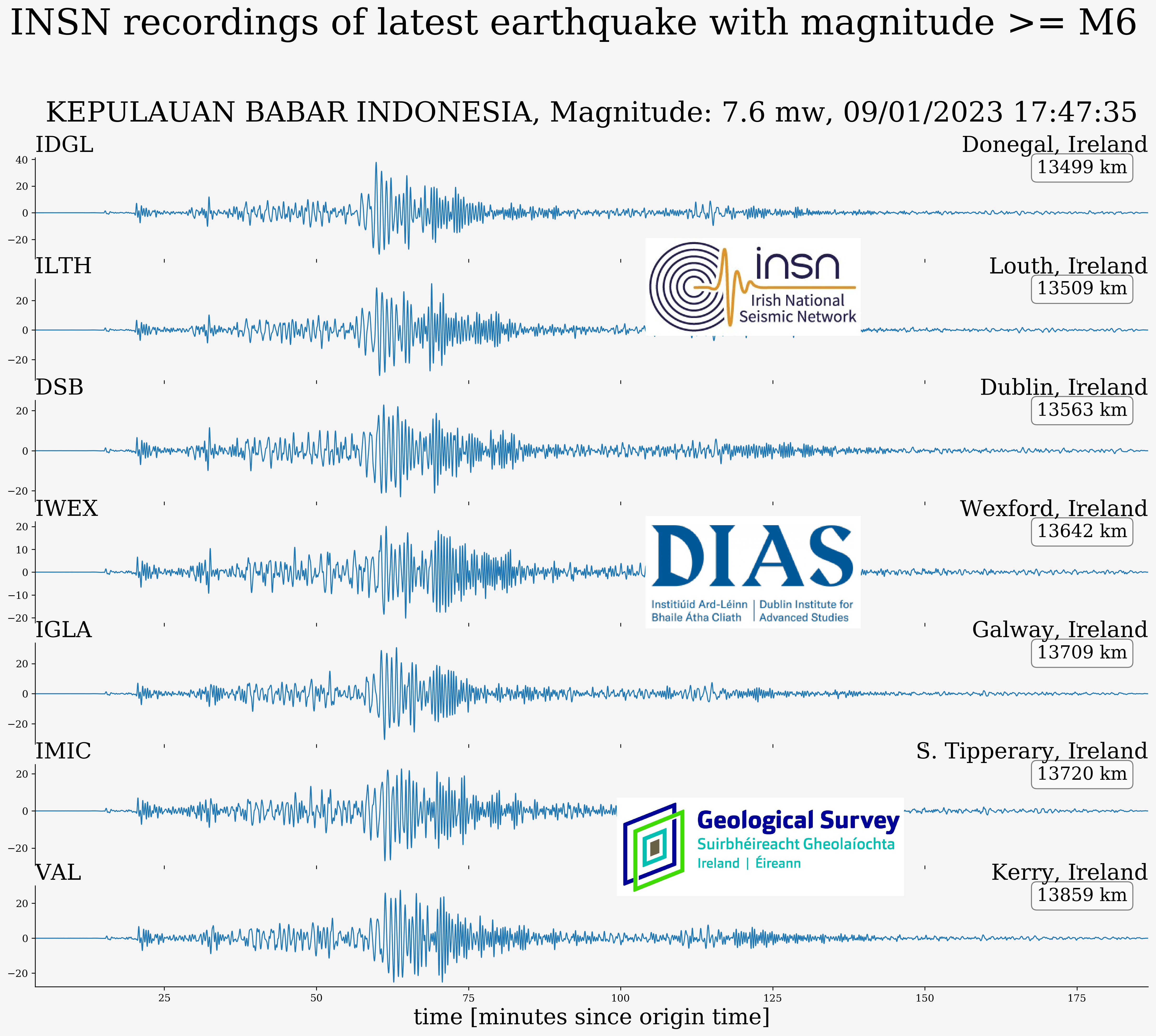
2023-01-09, M7.6, Indonesia
On the 9th of January 2023 an M7.6 earthquake occurred in the Tanimbar region of Indonesia (see map below). Several aftershocks were also reported after the powerful quake that was also felt in some parts of northern Australia.

Indonesia is positioned at the boundary of 3 tectonic plates (the Indian-Australian, Eurasian and Pacific plates). The plate boundaries are long and found beneath the ocean, meaning large and shallow earthquake can be generated from this zone that may potentially generate tsunami.
The event was recorded by seismic stations worldwide, including stations in the Irish National Seismic Network (INSN), see figure below.
More information is available at the following resources:
https://www.emsc-csem.org/Earthquake/earthquake.php?id=1208699
2022-12-20, M6.4, California
On the 20th of December 2022, an M6.4 earthquake occurred in the United States of America at 10:34:24 UTC approximately 15km WSW of Ferndale, California (see map below). At least two deaths have been recorded and several injuries. The earthquake also caused damage to buildings and interrupted the power and water supply in the area.

The event was recorded by seismic stations worldwide, including stations in the Irish National Seismic Network (INSN), see figure below.

More information is available at the following resources:
https://earthquake.usgs.gov/earthquakes/eventpage/nc73821036/executive
2022-11-21, M5.6, Indonesia
On the 21st of November 2022, an M5.6 earthquake occurred at 06:21:11 UTC approximately 18 km WSW of Ciranjang-hilir, Indonesia, see map below. The event occurred in a densely populated region and resulted in over 200 fatalities and over 1,000 injured people largely due to buildings collapsing.
This is a highly seismically active region, close to the subductive plate boundary between the Australia and Sunda plates. The earthquake occurred within the crust of the Sunda plate approximately 260km northeast of the boundary.

More information is available at the following resources:
https://earthquake.usgs.gov/earthquakes/eventpage/us7000ir9t/executive
https://www.bmkg.go.id/gempabumi/gempabumi-terkini.bmkg?lang=EN
https://www.emsc-csem.org/Earthquake/earthquake.php?id=1191326
2022-09-19, M7.6, Mexico
On the 19th of September, 2022, at 18:05:08 UTC a magnitude M7.6 earthquake occurred in the Michoacan region of Mexico. The earthquake struck approximately 110 km SE of the city of Colima (pop: 150,000), with the red circle indicating the epicentre on the map below. USGS reports the earthquake originated at a depth of 15 kilometers. At the time of writing the earthquake caused at least 2 deaths.

Tectonically, southern Mexico lies along the boundary between the North American plate and Cocos plate to the south. The subduction of the Cocos plate beneath the North American plate results in many large earthquakes in this region. Coincidentally, two other major earthquakes occurred in this region on the same date: the devastating M8.0 Mexico City earthquake on Sept 19th 1985 in which over 5,000 people died, and M7.1 Mexico City earthquake on Sept 19th 2017 which caused 360 fatalities.
The event was recorded by seismic stations worldwide, including stations in the Irish National Seismic Network (INSN), see figure below.

2022-08-12, M2.5, Celtic Sea
On the 12th of August 2022 at 00:30 UTC a magnitude M2.5 earthquake occurred in the Celtic Sea, approximately 200km south of Mizen Head, Co Cork. The earthquake located with a depth of 10 km. In the map below the epicentre of the earthquake is indicated with a red marker. Major fault zones in and around Ireland are shown with black lines. While earthquakes are known to occur in this region, it is not often that they are detected. As almost all seismometers are land-based, only larger magnitude events (M > 2) are seen from this region. The most recent earthquake detected in the Celtic Sea was M2.5, occurring on the 13th of July 2022, and the largest earthquake detected (since 1980) in the Celtic Sea was M2.9, occurring on the 27th of May 2019.

The event was recorded by the Irish National Seismic Network (INSN) and can be seen in the waveforms plotted below:


VAL - Kerry


IMAY - Mayo
