Home » Posts tagged 'Irish Sea'
Tag Archives: Irish Sea
![]()
2022-07-26, M0.3, Offshore Wexford
On the 26th of July 2022 at 23:33 UTC a magnitude M0.3 earthquake occurred offshore Wexford, locating approximately 12km east of Wexford town, at a depth of 3 km. In the map below the epicentre of the earthquake is indicated with a red marker. Major fault zones in and around Ireland are shown with black lines. This is the first Irish earthquake to be located using data from the recently installed underground seismic station at Mitchelstown Caves (IMIC). Earthquakes are regularly detected within county Wexford and the surrounding offshore regions. The largest earthquake detected in this area was M2.4, occurring on the 18th of March 2014 and locating 6km offshore Raven Point, Co. Wexford.


2020-12-11, M0.6, Irish Sea
On the 11th of December 2020 at 04:13:26 GMT, a magnitude M0.6 earthquake occurred in the Irish Sea approximately 40 km from the Wicklow coast. The earthquake occurred at a depth of 1 km. The epicentre location is indicated with a red circle in the map below, black lines denote major fault zones in and around Ireland. Earthquakes regularly occur in the Irish Sea, the most recent of which was M1.3, occurring on the 17th of September 2020. The largest magnitude event recorded in the Irish Sea in recent times was the M2.5 earthquake, occurring on the 15th of December 2019.

The event was recorded by the stations of the Irish National Seismic Network (INSN) and the British Geological Survey, and can be seen in the waveforms plotted below:

2020-09-17, M1.3, Offshore Skerries, North Dublin
On the 17th of September 2020 at 17:31:40 GMT, a magnitude M1.3 earthquake occurred in the Irish Sea approximately 2 km offshore Skerries, North Dublin. The earthquake occurred at a depth of 14 km. The epicentre location is indicated with a red circle in the map below, black lines denote major fault zones in and around Ireland. Earthquakes do occur regularly in the Irish Sea, however, it is not often that earthquakes are detected so close to Ireland’s east coast. The last detected earthquake to occur within 10 km of the east coast was the M2.4 event from the 18th of March 2013, occurring 6 km offshore Wexford.

The event was recorded by the Irish National Seismic Network (INSN) and can be seen in the waveforms plotted below:
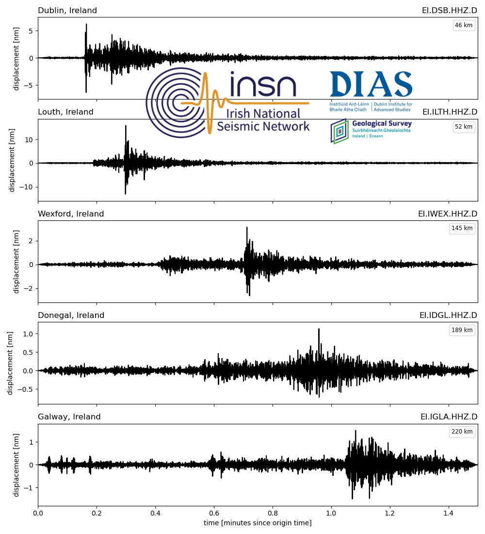
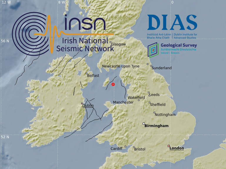
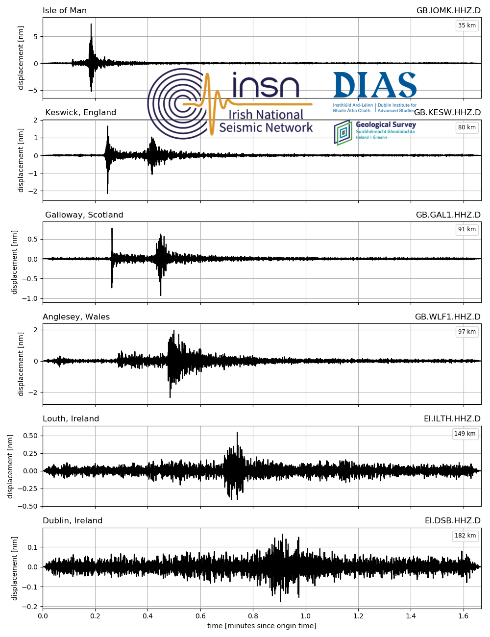
2020-05-14, M0.6, Irish Sea
On the 14th of May 2020 at 03:52:54 UTC, an earthquake of magnitude M0.6 occurred in the Irish Sea. The earthquake located approximately 20km east of the Isle of Man, and occurred at a depth of 3km. The epicentre location is indicated with a red circle in the map below, black lines denote major fault zones in and around Ireland. Events of this nature are not uncommon in the Irish Sea, with several small events (M < 1.1) detected near the Isle of Man in the past 5 years.
The event was recorded by the Irish National Seismic Network (INSN) and British Geological Survey (BGS) seismometers, for seismograms see the plot below (click image to enlarge).

VAL - Kerry


IMAY - Mayo
