Home » Posts tagged 'local earthquake' (Page 2)
Tag Archives: local earthquake
![]()
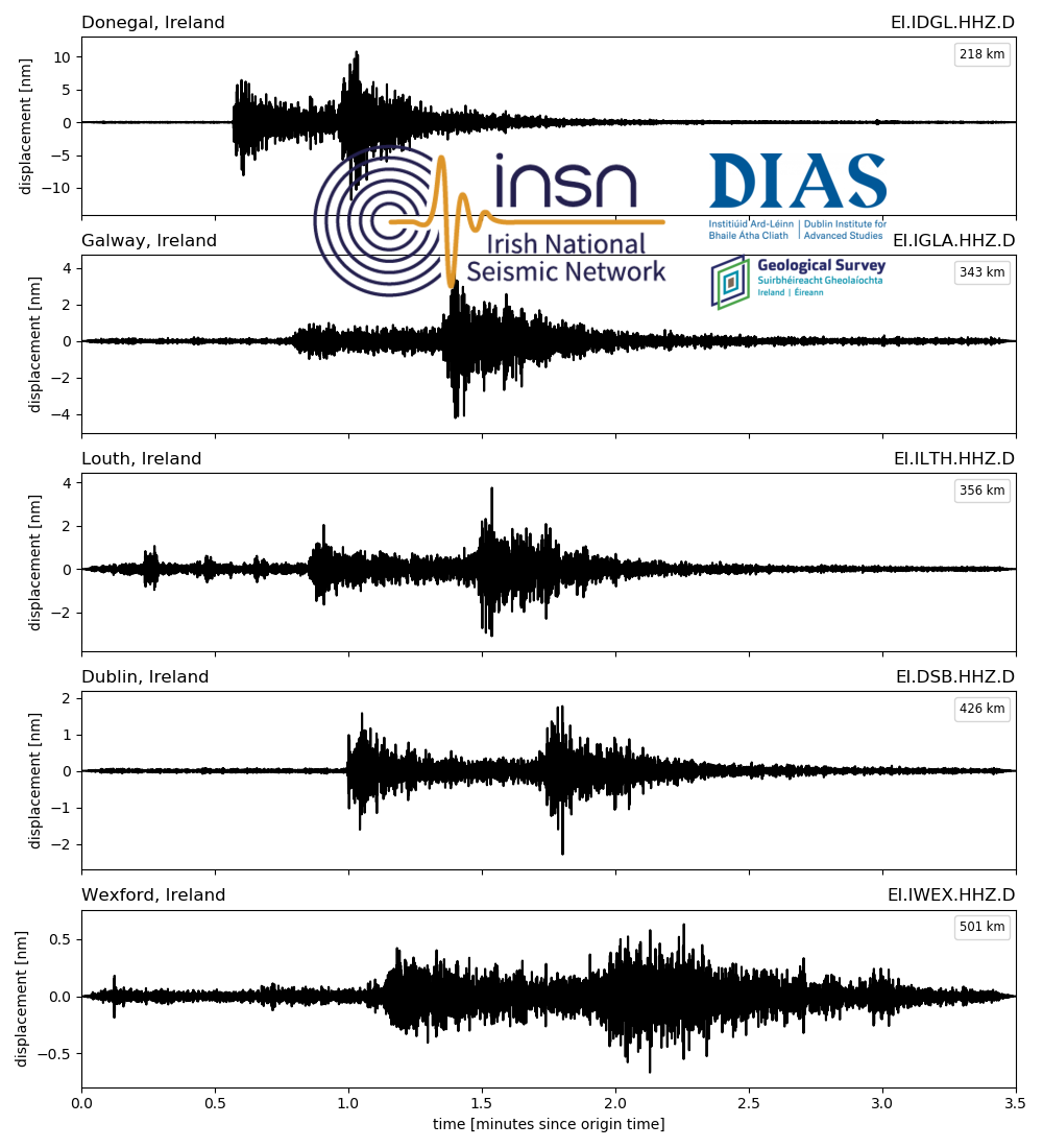
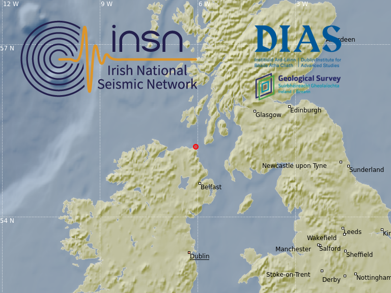
2021-11-16, M3.3, Scotland
On the 16th of November 2021 at 01:44 UTC a magnitude 3.3 earthquake occurred in Western Scotland. The earthquake located with a depth of approximately 6 km and is indicated by the red circle in the map below. There have been reports of the event being felt in Scotland and Northern Ireland.

The event was recorded by the stations of the Irish National Seismic Network (INSN) and can be seen in the waveforms plotted below:

Listen to Dr Martin Möllhoff discussing this event on RTE Radio 1’s Morning Ireland show here:
https://www.rte.ie/radio/radio1/clips/22030318/
More information is available from:
https://earthquake.usgs.gov/earthquakes/eventpage/us7000fugg/executive
https://www.emsc.eu/Earthquake/earthquake.php?id=1062853
http://www.earthquakes.bgs.ac.uk/earthquakes/recent_events/20211116014340.html#page=summary
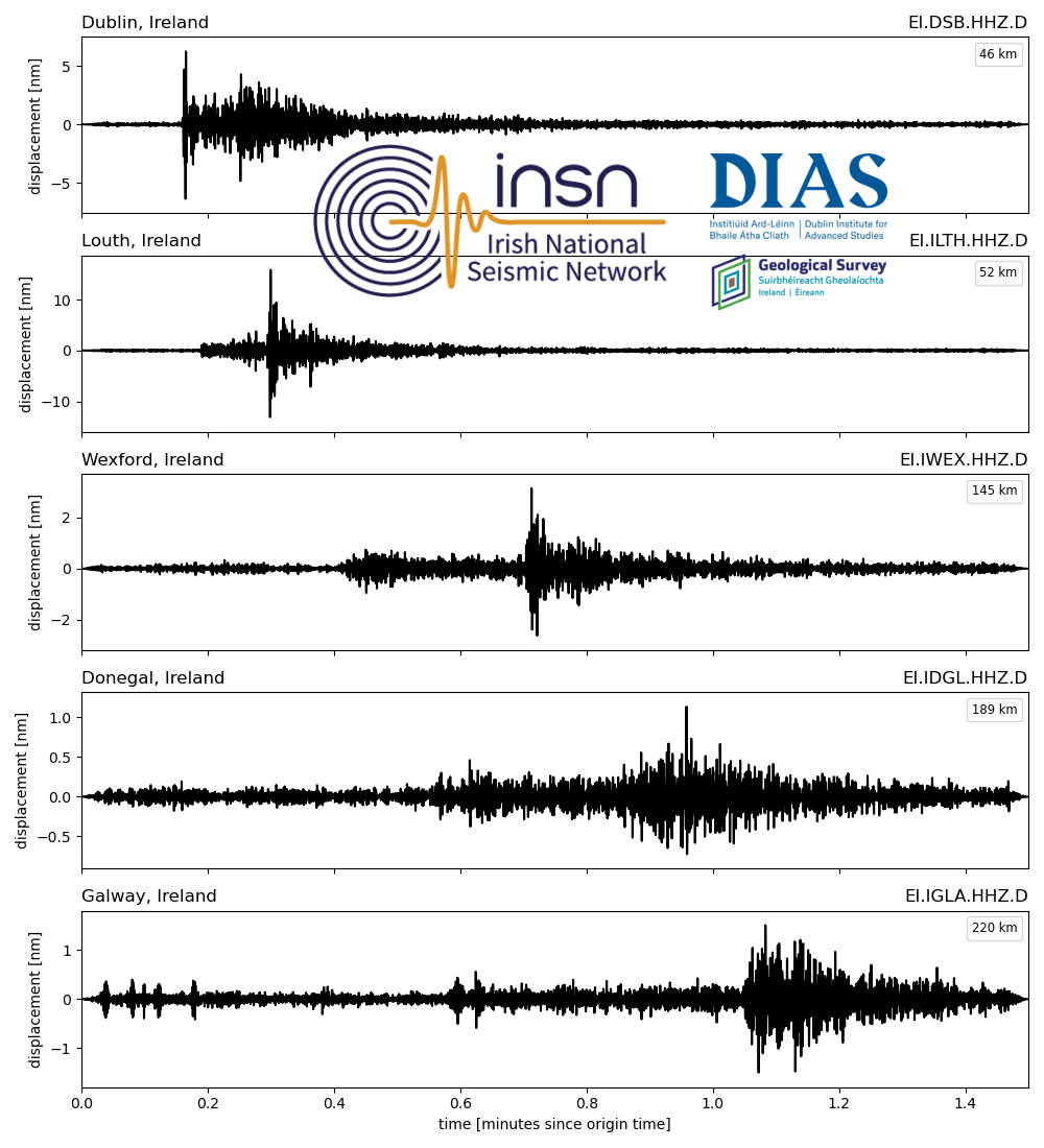
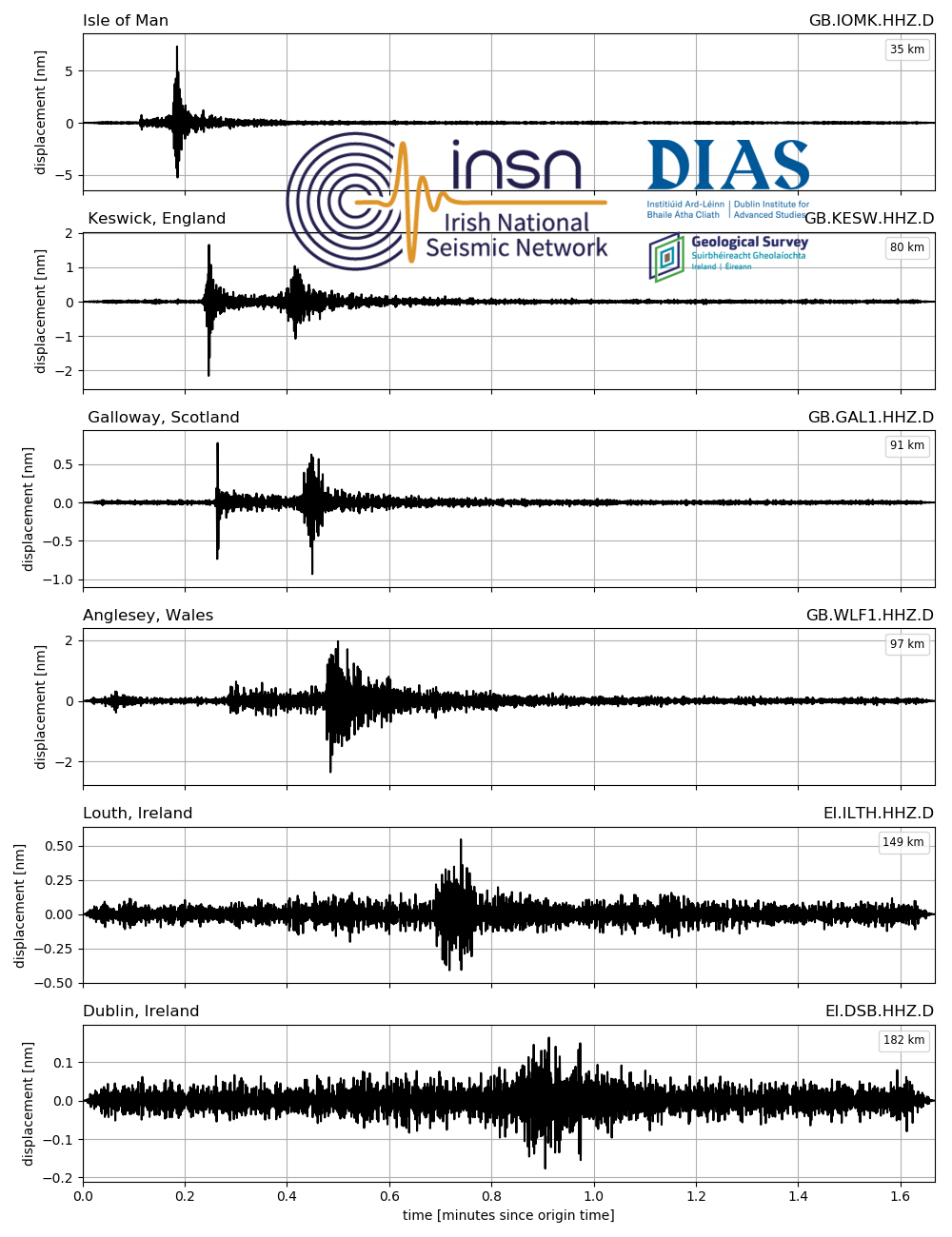
2021-03-31, M2.6 & M2.3, Rockall Trough
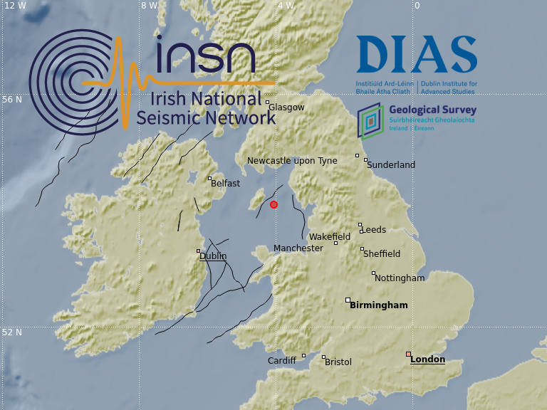
On the 31st of March 2021 at 02:47:08 UTC (03:47:08 local time), a magnitude M2.6 earthquake occurred in the Rockall Trough near the Hebrides Terrace Seamount, approximately 210 km north-northwest of Ireland. The epicentre location is indicated with a red circle in the map below, black lines denote major fault zones in and around Ireland. The earthquake occurred at a depth of 10 km, and was preceded by a magnitude M2.3 earthquake at the same location, occurring at 00:05:02 UTC (01:05:02 local time). Although earthquake detection rates in the Rockall Trough are lower than those of the Irish Sea, several events with magnitude M>2.0 have been detected in this region, most notably from 1980, when an earthquake of magnitude M4.0 occurred near the Hebrides Terrace Seamount.

The event was recorded by the stations of the Irish National Seismic Network (INSN) and can be seen in the waveforms plotted below:
2020-12-11, M0.6, Irish Sea
On the 11th of December 2020 at 04:13:26 GMT, a magnitude M0.6 earthquake occurred in the Irish Sea approximately 40 km from the Wicklow coast. The earthquake occurred at a depth of 1 km. The epicentre location is indicated with a red circle in the map below, black lines denote major fault zones in and around Ireland. Earthquakes regularly occur in the Irish Sea, the most recent of which was M1.3, occurring on the 17th of September 2020. The largest magnitude event recorded in the Irish Sea in recent times was the M2.5 earthquake, occurring on the 15th of December 2019.

The event was recorded by the stations of the Irish National Seismic Network (INSN) and the British Geological Survey, and can be seen in the waveforms plotted below:

2020-12-07, M0.6, Offshore Donegal
On the 7th December 2020 at 08:29:17 UTC a magnitude M0.6 earthquake occurred offshore Co. Donegal. The earthquake epicentre located approximately 12 km east of the island of Inistrahull, and 15 km northeast of the Inishowen peninsula. The earthquake occurred at a depth of 3 km. This is first time in which an event has been detected offshore northern Donegal, although several events have previously been detected offshore Antrim near Rathlin Island, and around the Scottish island of Islay. In the map below the epicentre of the earthquake is indicated with a red marker. Major fault zones in and around Ireland are shown with black lines.

The event was recorded by the Irish National Seismic Network (INSN) and can be seen in the waveforms plotted below:

2020-11-26, M2.5, Porcupine Abyssal Plain, North Atlantic
On the 26th of November 2020 at 04:29:59 UTC, a magnitude M2.5 earthquake occurred in the Porcupine Abyssal Plain, locating approximately 460km west-south-west off the coast of Kerry. The earthquake occurred at a depth of 10 km. The location of the epicentre is indicated with a red circle in the map below. While earthquakes are known to occur in this region, it is not often that they are detected. As almost all seismometers are land-based, only larger magnitude events (M > 2) are seen from this region. The previous two earthquakes from this area were detected in 2015 (M2.4 and M2.3), and the largest earthquake detected (since 1980) in the Porcupine region was M4.4, occurring on the 17th of February 1980.

The event was recorded by the Irish National Seismic Network (INSN) and can be seen in the waveforms plotted below:

2020-09-17, M1.3, Offshore Skerries, North Dublin
On the 17th of September 2020 at 17:31:40 GMT, a magnitude M1.3 earthquake occurred in the Irish Sea approximately 2 km offshore Skerries, North Dublin. The earthquake occurred at a depth of 14 km. The epicentre location is indicated with a red circle in the map below, black lines denote major fault zones in and around Ireland. Earthquakes do occur regularly in the Irish Sea, however, it is not often that earthquakes are detected so close to Ireland’s east coast. The last detected earthquake to occur within 10 km of the east coast was the M2.4 event from the 18th of March 2013, occurring 6 km offshore Wexford.

The event was recorded by the Irish National Seismic Network (INSN) and can be seen in the waveforms plotted below:
2020-05-14, M0.6, Irish Sea
On the 14th of May 2020 at 03:52:54 UTC, an earthquake of magnitude M0.6 occurred in the Irish Sea. The earthquake located approximately 20km east of the Isle of Man, and occurred at a depth of 3km. The epicentre location is indicated with a red circle in the map below, black lines denote major fault zones in and around Ireland. Events of this nature are not uncommon in the Irish Sea, with several small events (M < 1.1) detected near the Isle of Man in the past 5 years.
The event was recorded by the Irish National Seismic Network (INSN) and British Geological Survey (BGS) seismometers, for seismograms see the plot below (click image to enlarge).
2019-12-20, M1.4, Irish Sea
On the 20th of December 2019 at 09:53:44 local time, a M1.4 earthquake occurred in the Irish Sea approximately 90km north-east of Dublin and 40km south of the Isle of Man. The epicentre location is shown in the map below. This event follows a M2.5 earthquake in the Irish Sea from the 15th of December 2019. The M1.4 earthquake is most likely an aftershock of the recent M2.5 earthquake.

The event was recorded by the Irish National Seismic Network (INSN) and British Geological Survey (BGS) seismometers, and can be seen in the waveforms plotted below:

2019-12-18, M1.6, Offshore Antrim
On the 18th of December 2019 at 20:22:14 UTC, a M1.6 earthquake occurred offshore Co. Antrim, Northern Ireland. The earthquake located approximately 10km east of both Ballycastle and Rathlin Island, and at a depth of 1km. Since 2010, the Irish National Seismic Network (INSN) has previously recorded 5 earthquakes off the Antrim Coast, the largest of which was an M1.6 earthquake occurring on the 26th of October 2013.
The event was recorded by the Irish National Seismic Network (INSN) and British Geological Survey (BGS) seismometers, and can be seen in the waveforms plotted below:

The INSN is operated by the Dublin Institute for Advanced Studies (DIAS) in co-operation with the Geological Survey Ireland (GSI).

VAL - Kerry


IMAY - Mayo
